AI in Space Technology & Earth Observation Careers
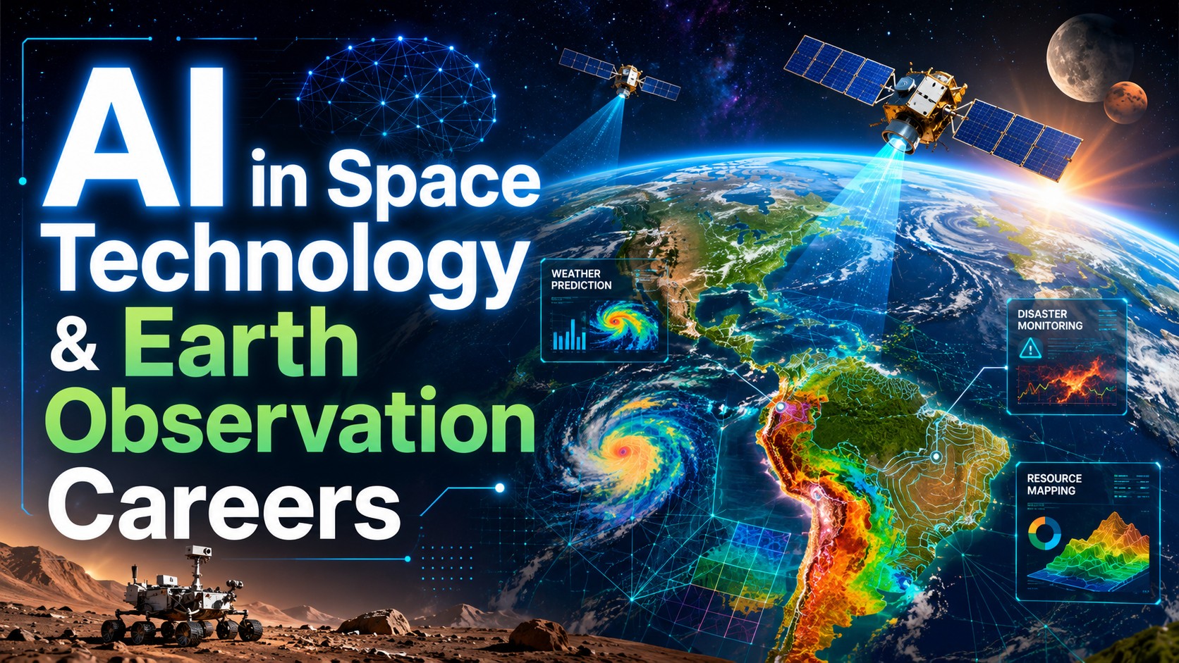
AI in Space Technology & Earth Observation Careers
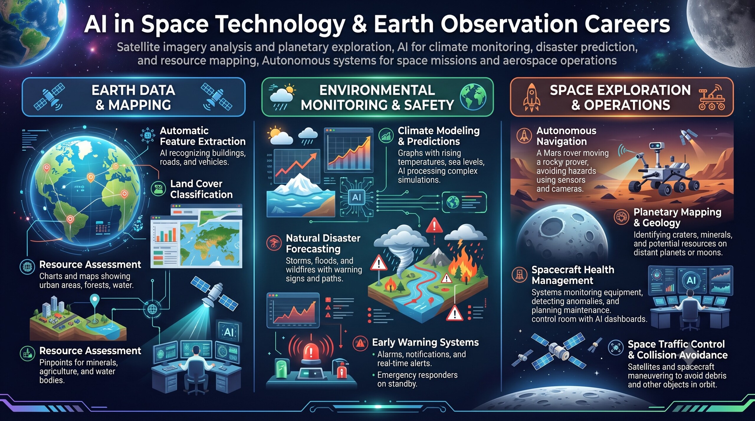
Satellite imagery analysis and planetary exploration, AI for climate monitoring, disaster prediction, and resource mapping, Autonomous systems for space missions and aerospace operations
Introduction
For most of the space age, satellites were primarily treated as data-collection machines. They photographed Earth, measured atmospheric and ocean conditions, monitored communications, and transmitted enormous quantities of information to ground stations. Human experts then spent days, weeks or even months processing the data and extracting useful conclusions.
Artificial intelligence is changing this model. AI can examine satellite images, identify patterns, detect changes and prioritize important observations far more rapidly than traditional manual methods. It can help scientists distinguish a flooded village from a permanent waterbody, identify early signs of forest stress, estimate crop health, detect illegal mining, map urban expansion and forecast the movement of dangerous weather systems.
The transformation is not confined to Earth. AI is also helping spacecraft navigate, plan activities, manage limited power, detect equipment problems and make decisions when communication with Earth is delayed or unavailable. In January 2026, NASA announced that its Perseverance rover had completed the first drives on another planet whose waypoints were planned using generative AI.
Let’s dive deep into this.
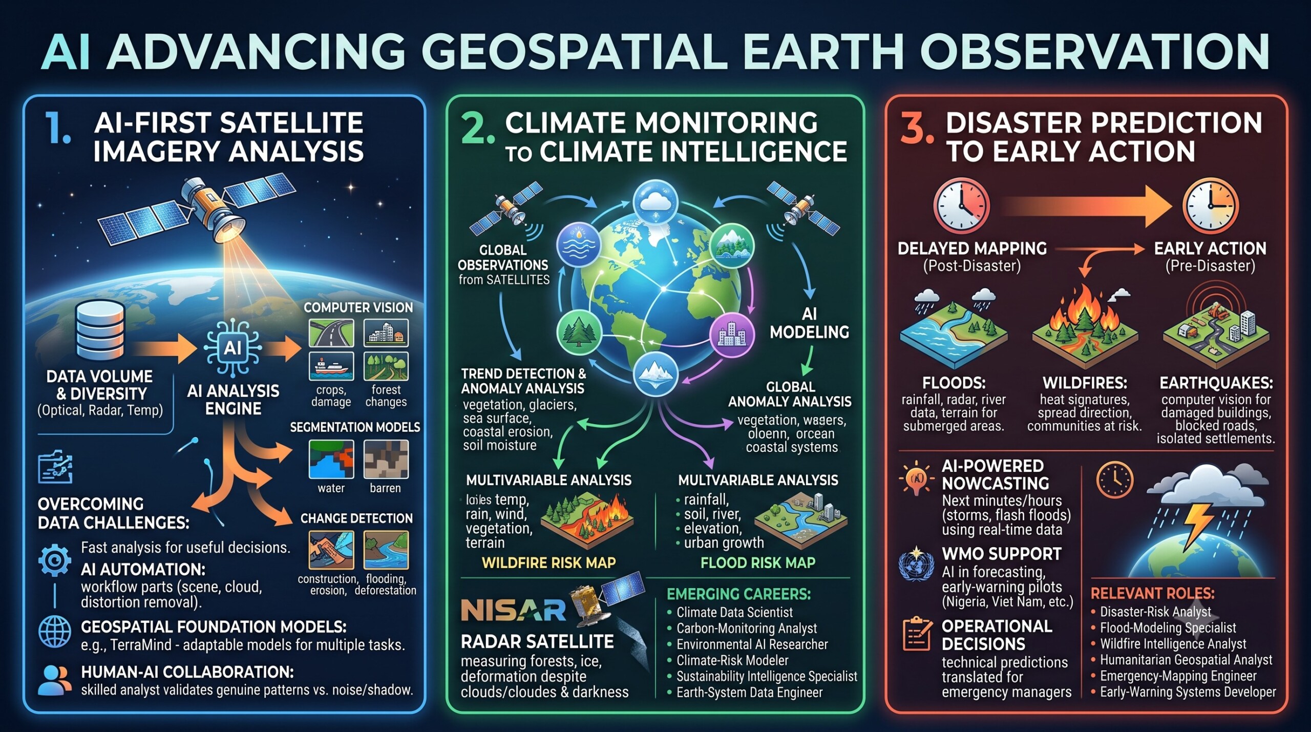
1. Satellite imagery analysis is becoming an AI-first profession
Satellite imagery is one of the most valuable sources of information available to governments, businesses, researchers and humanitarian organisations. Optical satellites record visible and infrared information, while radar satellites can observe the surface through clouds and darkness. Other instruments measure temperature, atmospheric gases, soil moisture, ocean colour, vegetation stress and surface elevation.
The difficulty is no longer simply collecting the data. The challenge is analysing it quickly enough to make useful decisions.
A single satellite mission can generate enormous volumes of images. Traditional analysis may require experts to inspect scenes, select useful spectral bands, remove clouds, correct distortions, classify land cover and compare images collected at different times. AI can automate large parts of this workflow.
Computer-vision models can be trained to recognise roads, buildings, ships, crop fields, solar farms, damaged structures and changes in forest cover. Segmentation models can assign every pixel to a category such as water, vegetation, urban land or barren terrain. Change-detection systems can compare two or more images and highlight where construction, flooding, erosion or deforestation has occurred.
The next stage is the rise of geospatial foundation models. Instead of training a separate model from the beginning for every task, researchers can adapt a large pretrained model to several Earth-observation applications. ESA and IBM’s TerraMind, released in April 2025, was designed to understand multiple forms of geospatial information, including satellite imagery, elevation, land-cover and location data.
A professional entering this field must understand both AI and the physical meaning of satellite data. A model may identify a pattern, but a skilled analyst must determine whether the pattern represents a genuine environmental change, a cloud shadow, seasonal variation, sensor noise or an error in image alignment. An excellent collection of learning videos awaits you on our Youtube channel.
2. AI is turning climate monitoring into climate intelligence
Climate monitoring requires the analysis of interconnected systems: atmosphere, oceans, forests, glaciers, agricultural land, soil and human settlements. Satellites provide repeated global observations, but converting those observations into usable climate intelligence requires complex modelling.
AI can help detect long-term trends and short-term anomalies across large geographical areas. It can analyse vegetation loss, glacier retreat, sea-surface temperatures, urban heat islands, coastal erosion, wildfire scars and changes in soil moisture. It can also combine satellite observations with weather records, ground sensors, economic information and climate models.
This combination is important because climate risk is rarely caused by a single variable. For example, wildfire danger can depend on temperature, rainfall, wind, vegetation dryness, terrain and human activity. Flood risk may involve rainfall intensity, soil saturation, river levels, elevation, drainage infrastructure and the growth of settlements in flood-prone areas.
AI systems can learn relationships among these variables and produce risk maps, forecasts and scenario assessments. They can help answer practical questions: Which districts are becoming more vulnerable to heat stress? Which forests are losing carbon-storage capacity? Where are coastlines retreating? Which agricultural areas are repeatedly exposed to drought?
NISAR is particularly relevant to this work because its radar instruments can measure changes in forests, wetlands, ice and Earth’s surface even when optical observation is limited by darkness or clouds. The mission is expected to support the study of ecosystem disturbances, ice-sheet changes, land deformation and natural hazards. careers emerging from this combination include climate data scientist, carbon-monitoring analyst, environmental AI researcher, climate-risk modeller, sustainability intelligence specialist and Earth-system data engineer.

3. Disaster prediction is moving from delayed mapping to early action
Satellite images have long been used after disasters to map damaged areas. AI is moving the field toward a more valuable objective: recognising danger early enough to protect people and infrastructure.
During floods, AI can analyse rainfall, radar imagery, river levels, terrain and historical flood patterns to estimate which areas may be submerged. During wildfires, it can identify heat signatures, estimate the direction of spread and locate communities or infrastructure at risk. After earthquakes, computer-vision systems can compare pre-disaster and post-disaster images to identify damaged buildings, blocked roads and isolated settlements.
AI-powered nowcasting is especially important for rapidly developing events such as thunderstorms, flash floods and intense rainfall. Unlike longer-range forecasting, nowcasting concentrates on what is likely to happen over the next few minutes or hours. It uses near-real-time information from satellites, radar and other observational systems.
The World Meteorological Organization has identified AI as an increasingly important component of forecasting, early-warning systems and disaster-risk reduction. In 2025, WMO highlighted AI-supported flood-forecasting pilots in countries including Nigeria, Viet Nam, Uruguay and the Czech Republic, where the systems helped identify signals that might otherwise have been missed. er possibilities extend beyond model building. Disaster intelligence requires people who can translate technical predictions into operational decisions. A mathematically accurate risk score is of little value unless emergency managers understand what it means, which communities are exposed and what action should be taken.
Relevant roles include disaster-risk analyst, flood-modelling specialist, wildfire intelligence analyst, humanitarian geospatial analyst, emergency-mapping engineer and early-warning systems developer. A constantly updated Whatsapp channel awaits your participation.
4. Resource mapping is creating careers across agriculture, water, energy and mining
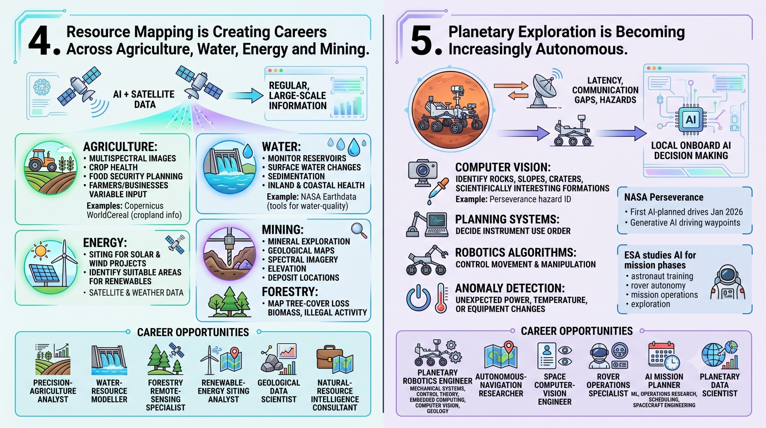
Natural resources are unevenly distributed, environmentally sensitive and frequently difficult to observe from the ground. Satellite data combined with AI can provide regular, large-scale information about crops, forests, waterbodies, minerals, coastal resources and energy infrastructure.
In agriculture, AI can analyse multispectral images to estimate crop type, crop health, irrigation patterns and possible pest or disease stress. Governments can use such information to improve food-security planning. Farmers and agriculture businesses can use it to target irrigation, fertiliser and field inspections.
The Copernicus Data Space Ecosystem already supports applications such as global crop monitoring through WorldCereal, which uses Earth-observation data to produce timely information about cropland and crop types. The platform provides open access to data from Sentinel missions covering land, oceans and the atmosphere. source applications include monitoring reservoirs, mapping surface-water changes, identifying sedimentation and examining the health of inland and coastal waters. In 2026, NASA’s Earthdata programme highlighted machine-learning-supported tools for retrieving water-quality information from satellite observations. lso assist in mineral exploration by combining geological maps, spectral imagery, elevation data and known deposit locations. In renewable energy, satellite and weather data can help identify suitable areas for solar and wind projects. In forestry, AI can map tree-cover loss, biomass and possible illegal activity.
Career opportunities include precision-agriculture analyst, water-resource modeller, forestry remote-sensing specialist, renewable-energy siting analyst, geological data scientist and natural-resource intelligence consultant.
5. Planetary exploration is becoming increasingly autonomous
Spacecraft exploring the Moon, Mars, asteroids and the outer Solar System cannot depend on continuous human control. Signals take time to travel, communication may be intermittent and unfamiliar terrain can create immediate hazards.
Autonomous systems allow a spacecraft or rover to observe its surroundings, evaluate possible actions and make limited decisions without waiting for instructions from Earth.
NASA’s Perseverance rover uses onboard imagery to identify hazards and navigate around them. In December 2025, it completed two demonstrations in which generative AI helped create driving waypoints that would normally have been planned manually by human rover drivers. NASA announced the achievement in January 2026 as the first AI-planned drives performed on another world. ontribute to planetary missions in several ways. Computer vision can identify rocks, slopes, craters and scientifically interesting formations. Planning systems can decide the order in which instruments should be used. Robotics algorithms can control movement and manipulation. Anomaly-detection systems can identify unexpected changes in power, temperature or equipment behaviour.
ESA has similarly been studying AI across mission phases, including astronaut training, rover autonomy, mission operations and exploration on other planets. Its work on autonomous navigation includes spacecraft that combine information from several sensors to build a model of their surroundings and make onboard decisions. oles include planetary robotics engineer, autonomous-navigation researcher, space computer-vision engineer, rover operations specialist, AI mission planner and planetary data scientist.
These careers require an unusual combination of disciplines. A planetary robotics engineer may need knowledge of mechanical systems, control theory, embedded computing, computer vision and geology. An AI mission planner may combine machine learning with operations research, scheduling and spacecraft engineering. Excellent individualised mentoring programmes available.
6. AI will manage spacecraft health, mission planning and aerospace operations
Not every important space career involves interpreting images or driving a rover. AI is also changing the operational systems that keep spacecraft, satellites, launch vehicles and aviation platforms functioning.
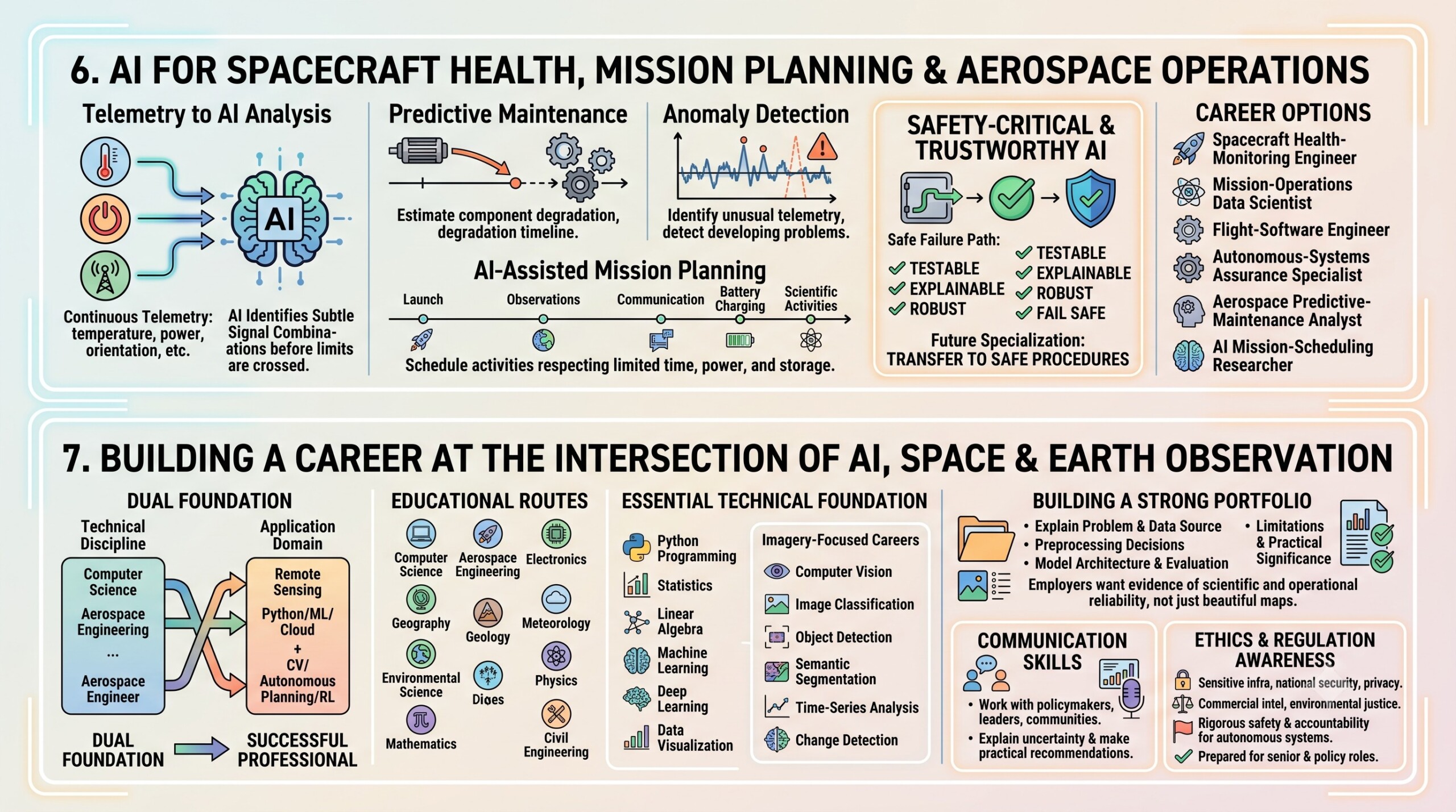
A spacecraft produces continuous streams of telemetry describing its temperature, power, orientation, communication status and instrument performance. Engineers traditionally monitor these values through predefined limits and operational procedures. AI can identify subtle combinations of signals that may indicate a developing problem before a simple threshold is crossed.
Predictive-maintenance systems can estimate whether a component is degrading. Anomaly-detection models can identify unusual telemetry. AI-assisted mission-planning systems can schedule observations, communication windows, battery charging and scientific activities while respecting limited time, power and storage.
Career options include spacecraft health-monitoring engineer, mission-operations data scientist, flight-software engineer, autonomous-systems assurance specialist, aerospace predictive-maintenance analyst and AI mission-scheduling researcher.
These professionals must understand that aerospace AI is safety-critical. Accuracy alone is insufficient. Systems must also be testable, explainable, robust to unusual conditions and capable of failing safely.
A major future specialisation will be trustworthy AI for space: designing systems that know when they are uncertain, explain the basis of their decisions and transfer control to a safer conventional procedure when necessary.
7. Building a career at the intersection of AI, space and Earth observation
There is no single educational route into this field. A student may begin with computer science, aerospace engineering, electronics, geography, geology, meteorology, environmental science, physics, mathematics or civil engineering.
The most successful professionals will develop a “dual foundation”: one strong technical discipline and one strong application domain.
Someone with a computer-science background might specialise in remote sensing, climate science or planetary robotics. A geographer or environmental scientist might build skills in Python, machine learning and cloud data processing. An aerospace engineer might learn computer vision, autonomous planning and reinforcement learning.
The essential technical foundation includes Python programming, statistics, linear algebra, machine learning, deep learning and data visualisation. For imagery-focused careers, candidates should learn computer vision, image classification, object detection, semantic segmentation, time-series analysis and change detection.
The portfolio should explain the problem, source of the data, preprocessing decisions, model architecture, evaluation method, limitations and practical significance. Producing a beautiful map is not enough. Employers want evidence that the candidate understands whether the output is scientifically and operationally reliable.
Communication is another important skill. Space and climate professionals frequently work with policymakers, business leaders, emergency managers and communities that may not understand model architecture or remote-sensing terminology. The ability to explain uncertainty and convert technical findings into practical recommendations is therefore a major career advantage.
Candidates should also develop an awareness of regulation and ethics. Satellite analysis can involve sensitive infrastructure, national security, privacy, commercial intelligence and environmental justice. Autonomous aerospace systems require rigorous safety and accountability. Professionals who understand responsible AI will be better prepared for senior technical and policy roles. Subscribe to our free AI newsletter now.
Conclusion
AI in drug discovery, genomics, and precision medicine is one of the most promising career areas of the coming decade. It brings together the power of computation with the complexity of biology and the human importance of medicine.
AI can help discover molecules faster, model proteins more accurately, analyze genomes more deeply, personalize treatments, and improve clinical trials. But the success of this field depends not only on algorithms. It depends on collaboration between AI experts, biologists, clinicians, pharmaceutical teams, regulators, and patients.
For students and professionals, this is a field of great opportunity. A person does not need to know everything on day one. A biologist can learn AI step by step. A programmer can learn life sciences step by step. A doctor can learn how AI supports clinical decisions. A pharma professional can learn how data-driven tools improve research and development.
The future of medicine will not be built by AI alone. It will be built by people who know how to use AI wisely, scientifically, ethically, and collaboratively. Upgrade your AI-readiness with our masterclass.